In today’s rapidly changing world, Geographic Information System (GIS) solutions have become indispensable for businesses and organizations. These solutions enable business institutions to leverage geospatial data effectively and make informed decisions. Among the leading providers in Nigeria, Polaris Digitech stands out as the best GIS Service Provider in Nigeria. With our commitment to excellence and cutting-edge technology, Polaris Digitech is revolutionizing the way businesses and organizations in Nigeria leverage geospatial data to make informed decisions.
Unmatched Expertise
Polaris Digitech has a team of skilled GIS professionals with diverse industry experience in urban planning, telecom, and more. Our expertise enables us to understand client’s unique challenges and customize solutions to meet their specific requirements. With extensive knowledge and experience, Polaris Digitech as a provider of Geographic Information System(GIS) service providers ensures the delivery of top-quality GIS services to our customers. We adapt our solutions to various sectors, including environmental management, to provide effective and tailored services. Polaris Digitech’s highly skilled team guarantees the highest quality GIS services that address clients’ specific needs.
Comprehensive Geographic Information System Services
Polaris Digitech Limited is the best GIS Service Provider in Nigeria because we offer a comprehensive range of GIS services tailored to the diverse needs of their clients in Nigeria. These services include:
1. Data Collection and Analysis
Polaris Digitech excels in geospatial data collection and analysis, leveraging advanced proprietary tools and techniques. Our use of remote sensing and GPS methods ensures the accuracy and currency of collected information. By harnessing geospatial tools, we empower organizations with valuable insights for informed decision-making. Polaris Digitech enables organizations to make reliable and precise choices by utilizing accurate geospatial data. Through cutting-edge tools and techniques, Polaris Digitech helps organizations gain valuable insights from geospatial data.
2. Web and Mobile GIS Applications
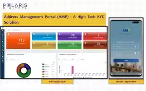
Polaris Digitech creates easy-to-use web and mobile apps for clients to access and view spatial data anywhere. Our applications feature intuitive interface designs that prioritize user-friendliness. Additionally, our apps seamlessly integrate with existing systems, optimizing workflow efficiency. Polaris Digitech enables organizations to effectively utilize their spatial data through our integrated applications. We prioritize user convenience by developing intuitive, seamlessly integrated web and mobile apps for spatial data access. Some of our GIS applications include;
3. Spatial Database Management
Managing large volumes of geospatial data can be challenging without proper database management. Polaris Digitech addresses this challenge by providing efficient storage, organization, and retrieval of spatial data for their clients. With our expertise in spatial database systems, we ensure optimal data integrity and performance by maximizing the value of spatial data for our clients.
4. Mapping and Cartography
Polaris Digitech excels in producing captivating maps and cartographic representations that effectively communicate spatial information. Our team of experts and talented professionals pays meticulous attention to detail and employs creativity to create visually appealing maps. These maps not only enhance the understanding of spatial data but also aid in decision-making processes for businesses and organizations in Nigeria.
Commitment to Quality and Innovation
Polaris Digitech is committed to delivering exceptional quality and continuous innovation in the field of GIS. We stay abreast of the latest GIS trends and advancements, ensuring that our clients benefit from state-of-the-art solutions. By combining our domain knowledge with cutting-edge technology, Polaris Digitech empowers organizations in Nigeria to streamline operations, improve efficiencies, and gain a competitive edge in their respective industries.
Client-Centric Approach
At Polaris Digitech, client satisfaction is at the center of everything we do. We understand that every client has unique requirements and challenges. Therefore, we collaborate closely with clients take time to understand their specific needs, and tailor GIS solutions accordingly. Polaris Digitech provides ongoing support, training, and consultation to ensure that our clients achieve their objectives and maximize the potential of GIS technology in their organizations.
Conclusion
Polaris Digitech’s unwavering commitment to excellence, unmatched expertise, and comprehensive range of GIS services make them the ideal choice for organizations in Nigeria seeking reliable and innovative geospatial solutions. By harnessing the power of GIS technology, Polaris Digitech helps clients unlock the full potential of their spatial data, revolutionizing how decisions are made and businesses thrive in today’s data-driven world. With our trusted partnership, businesses and organizations in Nigeria can confidently navigate the complexities of geospatial information and make informed decisions that drive success.


