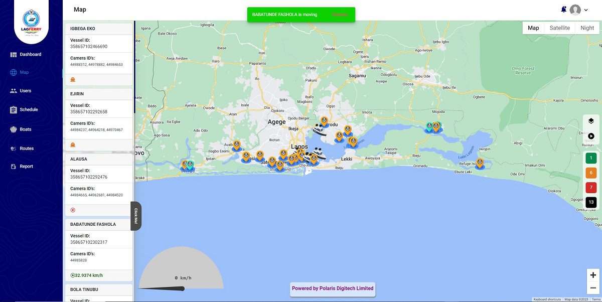
A Geo-enabled Surveillance center has been birthed by Polaris Digitech Limited. A renowned provider of Geospatial Business Solutions, specializing in real-time location intelligence technology. With vast experience and expertise in developing bespoke applications, Polaris Digitech is at the forefront of cutting-edge geospatial solutions. In this transformative project, Polaris Digitech took on the challenge of creating and deploying a geo-enabled surveillance center for Lagos State Ferry Services.
About LAGFERRY
LAGFERRY is the principal ferry services provider in Lagos State, responsible for the operational aspects of water transportation. Ensuring the safe and efficient movement of people and goods across waterways is a fundamental part of their mission.
Vertical/Horizontal Solution:- Government
Primary Project Location:- Lagos, Nigeria
The Challenges
Several challenges needed to be overcome in this project:
1. Camera Placement: Finding the ideal spots to install cameras on boats for optimal tracking and monitoring.
2. Solar Panel Durability: Ensuring the solar panels used for power wouldn’t break or degrade in the harsh marine environment.
3. Data Integration: The efficient transfer of captured terminal and route points to the Google Maps Platform was essential for real-time tracking.
The Solutions
Polaris Digitech Limited delivered a comprehensive solution – the LAGFERRY Vessel monitoring application for Lagos State Government. This application provided real-time monitoring, trip scheduling, live reporting, and vessel management services.
Key to its functionality was the integration of Google Maps, which was utilized on the map interface of the application. The data from onboard trackers combined with Google Maps provided a robust visual representation for alerts, tracking of moving vessels, and managing offline and online vessels.
The Result (Geo-enabled ICT Surveillance Center)
The implementation of this innovative solution resulted in the establishment of a Geo-enabled Information Technology Surveillance center for Lagos Ferry Services. This surveillance center has empowered Lagos State to monitor and track the operations of LAGFERRY vessels and the activities of its operatives in real-time.
By partnering with Polaris Digitech Limited, LAGFERRY experienced a profound transformation in its operations. Here’s how the project brought about these transformative changes:
1. Enhanced Safety: The ability to monitor vessel locations in real-time meant that LAGFERRY could respond promptly to any emergencies or issues, significantly enhancing the safety of water transportation.
2. Operational Efficiency: The application’s trip scheduling and vessel management features optimized the allocation of resources and the management of the fleet, reducing operational costs and improving efficiency.
3. Improved Customer Experience: Passengers benefited from the live reporting app, which allowed them to provide feedback and report issues. This improved customer service quality and satisfaction.
4. Data-Driven Decision-Making: The real-time tracking and reporting capabilities provided valuable data that LAGFERRY could use for data-driven decision-making and route optimization.
Lagos State Government Announcement
The Lagos State Government has promised to improve investment in the state’s transportation sector with the plan to deliver more innovative interventions in water transportation. Making this known during a scheduled visit to Lagos Ferry Services (LAGFERRY) operational base at Mile 2 Terminal, the Commissioner for Transportation, Mr. Oluwaseun Osiyemi, said the water transportation industry in Lagos will be a model for other states across the country.
Expressing delight over the newly launched E-fleet Surveillance System, Osiyemi commended the management of the agency, revealing that the State Government will continue to support LAGFERRY in achieving its plan of ferrying 30% of Lagosians via the waterways.
Technologies Used
– Google Cloud Platform
– Google Maps
Conclusion
The partnership between Polaris Digitech Limited and Lagos State Ferry Services resulted in a remarkable success story. This project demonstrated the power of real-time location intelligence and geospatial technology in enhancing safety, efficiency, and customer satisfaction in the realm of water transportation. Polaris Digitech’s expertise and innovative solutions have made us a true leader in the geospatial industry, driving positive change for our clients and the communities we serve


